
Source: in-cyprus.philenews.com
More than half of 2,060 boat sightings recorded by satellite in three Cyprus marine protected areas over the past two summers could not be matched to vessel tracking data, a study has found.
Sightings with no tracking match may reflect legal activities such as tourism and leisure boating. However, they could also point to undeclared or potentially illegal activity at sea, including fishing and the transport of goods. The three areas protect meadows of the seagrass Posidonia oceanica, which grows so slowly that damage done in seconds can last for decades.
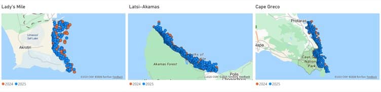
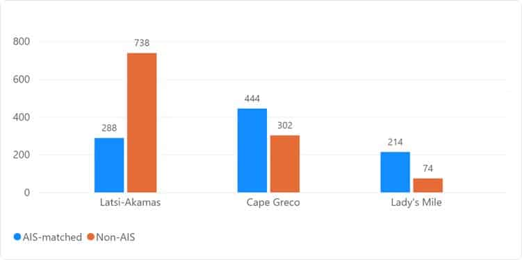
The study covered Lady’s Mile, Latsi-Akamas and Cape Greco during selected summer periods in 2024 and 2025. It was carried out by PERIOPSIS Ltd, the Marine and Environmental Research (MER) Lab and Finn Lageveen, a Creative Technology student at the University of Twente in the Netherlands. Of the 2,060 detections, 1,114, or about 54 per cent, did not correspond to an available signal from the Automatic Identification System (AIS), which ships use to broadcast their identity and course.
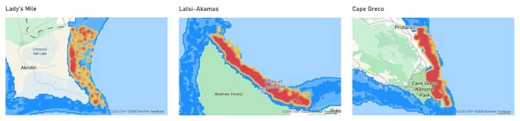
Posidonia meadows serve as nursery and feeding grounds for marine species, support biodiversity, and help protect the coastline and store carbon. Heat maps combining the boat sightings with Posidonia data from the Department of Environment showed that, in most cases, the areas with the highest concentration of detections coincided with protected Posidonia meadows.
Latsi-Akamas busiest
Latsi-Akamas accounted for almost half of all detections and was the busiest of the three areas on observation days in both years. Of its 1,026 detections, 738 had no AIS match. Cape Greco recorded 746 detections, of which 444 matched AIS data and 302 did not. Lady’s Mile recorded 288, with 214 matched and 74 unmatched.
Across the three areas, sightings in July and August were about 17 per cent lower in 2025 than in 2024. Activity fell at Latsi-Akamas and Lady’s Mile, with the biggest drop at Lady’s Mile, while Cape Greco stayed broadly stable. Allowing for differences in the number of satellite observation days, activity was lower in June and rose in July and August. August was the busiest month in both years.
Anchoring pressure
About 60 per cent of detections in the sample were of boats classed as stationary at the time of observation. That does not confirm the boats were anchored, but it helps identify areas that may need closer monitoring.

Anchors and chains can damage Posidonia meadows, a priority habitat, when they are repeatedly dropped on or dragged across the seabed. Anchoring is recognised as one of the significant impacts of leisure boating in Mediterranean marine protected areas. WWF reports on Mediterranean seagrass meadows list Cyprus among the areas under the greatest anchoring pressure.
Satellite monitoring
The analysis used an AI-based vessel detection service from PERIOPSIS, which spots boats at sea using visible-light satellite images. The images do not reconstruct each boat’s full route, but they show where boats repeatedly appear and where activity is concentrated. Because the analysis relies on one satellite image a day, the actual number of detections may be significantly higher than the 2,060 recorded.
According to a press release on the findings, satellite technology is not meant to replace patrols or existing vessel monitoring systems. It can complement them as an independent source of extra information, helping authorities and environmental organisations focus where the need is greatest.
The press release said the data could give policymakers and environmental authorities clear, evidence-based information on the extent and spread of boat activity in sensitive marine protected areas. It could also support the case for early action, so that designating an area as protected translates into effective protection and long-term conservation results.